The hike is 8 miles from the trailhead to the village of Supai, in the canyon where they reside. The lodge is in the village and the campground is 2 miles past the town. It's a moderate-to-difficult hike which people say takes 3-3.5 hours to get down, and around 7 to get back up to the trailhead.
This trip was a dream of mine to do for several years, and something my college friend, Kim and I thought about doing last year-- until we learned of the reservation process. This hike is through tribal lands, so a reservation is required in advance to hike. Reservations for the year open on February 1, and are taken by phone only. You call. And call. And call. Kim and I both called for two weeks straight, at least 100 times a day. Kim finally got through and the only dates available were in August, during monsoon season. Not ideal, but we jumped on them and thankfully the weather was good to us! There was a recent article in the local paper talking about how the tour group buy up a significant number of the available reservations, making it tough for individuals to purchase.
The trailhead is around an hour's drive into the reservation land, and close to an hour-and-a-half from the next town. We decided to stop in Seligman to grab a last bite, and ate at Westside Lilo on Route 66. It's an American-German restaurant founded by a German immigrant twenty years ago.
The road to the trailhead, Indian Road 18, has a lot of loose animals (mostly cows that we saw) so it's recommended to drive during daylight hours. The trail into Supai begins at Hualapai Hilltop where there is a fair-sized parking lot, some composting toilets, a small office and a locals that sell snacks and cold drinks from a truck. We made it to the lot at 8 pm, and barely had enough time to wash our faces and use the bathroom before the deluge started. It started drizzling and quickly turned to one of the heaviest monsoon rains I have seen. I'll admit that I had some concerns about flooding in the canyon.


A local woman approached us shortly after we pulled in to ensure that we had reservations, and told us that a surprising number of people just show up without knowing they are required. We actually met three girls from the Netherlands who made it down to the campground, not only without reservations but also without a tent! Amazingly they were not turned away (we were unsure if it was due to the coming storm, as another person told us he knows of people who were turned away. There is actually a sign at the trailhead that day hiking is not permitted.)
We began the descent as the sun was rising after dropping off our larger pack. We watched the canyon open up in color, beautiful shades of umber, gold and tan. Every hour or so the landscape changes, presenting more beauty and interest. The descent is steep, then the canyon floor morphs to large crushed rocks and finally a silt which is challenging to walk in. The descent is around 2 miles, then 6 miles of sloping grounds to get to Supai. We were passed by several trains of horses and donkeys, which run right past you.


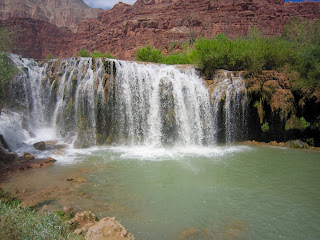
The first three waterfalls are before you reach Supai. First is the New Navajo falls followed closely by Fifty Foot Falls. There are a lot of beautiful rock formations in the water after these falls which make a lovely curtain down to creek. Upon entering the campground is the third, Havasu Falls and it is stunning! It's high and roars down into a large pool where you can swim and enjoy the magestic beauty. We hiked down and had planned well, bringing bathing suits in our packs so we changed and took a swim.


Our packs arrived a few hours later so we set up camp. We were told by the ranger to pick a camp on high ground away from the creek. Comforting! We found a great place with a good tree cover, away from the creek but near the water and the toilets. The water source for the campground is from a spring, sourced through rock by a metal pipe. It was fresh, cool and a luxury. We selected a site away from the creek as even though it was cooler by the creek, we thought it a good idea during monsoon season where there are flash floods to not be so close. Home sweet home.

We settled in the first afternoon, made dinner of freeze-dried goodness, got washed up and no sooner did we finish when the rain started. It was ok as we were tired from the hike and figured we'd be early to bed anyways.
We were a bit lazy the next morning and got up slowly, enjoying a leisurely start. We made some coffee and tea, made breakfast and headed out to the back of the campground to Mooney Falls.
Mooney Falls


Those who know me know of my rather extreme fear of heights, or more accurately, fear of falling. I'm fine in glass elevators and on ferris wheels, but if I feel I can fall, I lose my mind. Well, this was no different. The reservation is unlike most of the US, where our litigious nature has required extensive installation of safety features. Here, a simple, "Proceed at your own risk" sign is hung before the steepest descent I have ever seen. The first third was pretty extreme, followed by a fairly tight, very steep descent through a cave. Sound like fun? Nah. I got out and proceeded to panic at the landing, while two dozen people squeezed in past me to continue. I'll admit it-- game over for me. I wanted to do it but not badly enough. And given that I pulled a muscle on the hike down, AND I had to hike back out the following day, it also didn't seem smart to push it. I don't regret it.
Kim proceeded on so the pictures of Beaver Falls and the area surrounding are from her. The pictures above show just a small view of what she climbed to get down: Ladders bolted into the wall, two chains and toe holds unevenly carved into the rocks. When she described it to me I felt physically ill. Another sign that I made the right call.
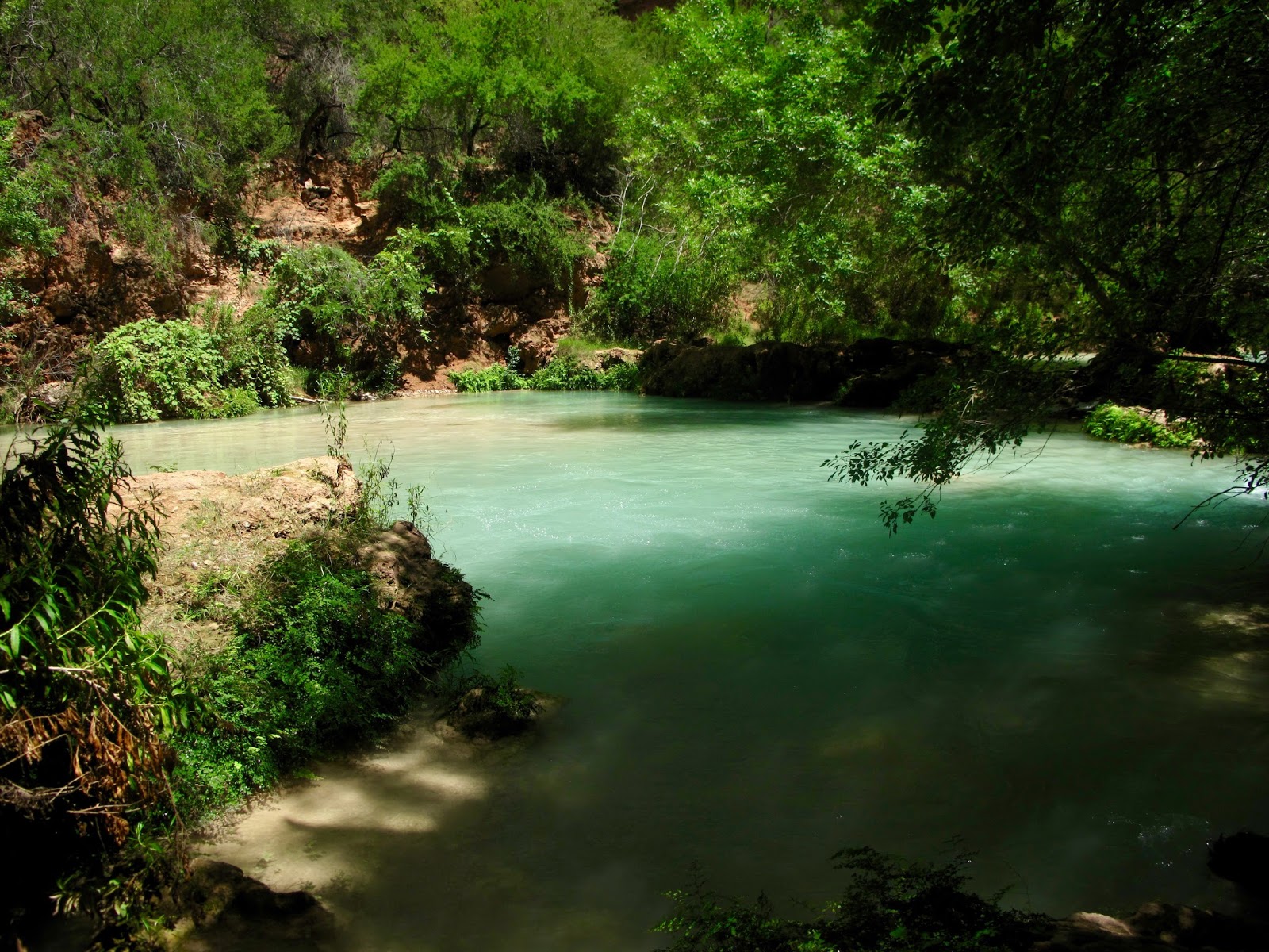
Instead, I spent a while at the source of Mooney Falls, high above where the creek collects its volume and power before descending. I even dunked my feet there and enjoyed the cool rush. I went back to Havasu Falls for a dunk, and had a lovely, refreshing nap. I was surprised Kim wasn't back for around five hours, and learned that the two miles from Mooney to Beaver are rather windy with many stops and starts finding the right trail (though our experience was that most trails lead to the same place and are well marked.) She walked on a 2x4 over the creek, a slotted 'bridge', and also got to see the area called the Jungle, a viney mess of lush green vegitation.


Kim got back at around 4 so we caught up, then headed back to the Havasu Falls area. We decided in indulge and got an Indian Fry Bread from a local selling them. We met three girls from the Netherlands that I mentioned above, hiking with 10 little bottles of water, no tent and not really any gear. They had one backpack between then. It was so interesting to talk with them! One is living in NY state as a nanny and the other two are still in the Netherlands.
We got up a little after four to break down camp, grab a quick bite and head out. Our plans to move quickly faded with the early morning wake-up and we ended up heading out at 5:45. We were told the hike would take 7-7.5 hours.
Havasu Falls- photo credit to Kim Baymiller


We got to the base of the climb up when we expected to and took a break in the shade. We expected it to be the last shade we'd see for a while though thankfully, we did find a patch two other times. The ascent was slow and felt long, but we took a few 5 minute breaks and kept plugging along. I was glad to be off the silt and crushed rock as it was easier to walk (not like a drunken sailor at times!) Just when I was about to call another break, we saw it-- the top! The building of composting toilets loomed up above only a few lengths of switchback away! We dragged ourselves onward, nearly getting trampled by the donkeys at one point as we did our best to get off the trail but didn't quite manage it.
Success!! We did decide to have donkeys carry our packs and took day packs instead-- which, with two water bladders, snacks and some safety items weren't a light load. The donkeys that nearly ran us over had our gear, and they were unloaded as we caught our breaths, got some fresh cool water from the car and talked with others about their trips. Our neighbor campsite that took the helicopter down also took it up, as while it wasn't running for rides that day, his girlfriend got very sick and had to be taken out. (She will be ok.)
We tried several times to take jumping pictures with no luck, as our leaden feet wouldn't lift much from the ground. So this is what we got!
This hike is amazing and well worth it. I had said that this was the last thing I absolutely had to do before leaving AZ, in part, as there were a couple of things I didn't get to do before I left New England but felt I'd be back to do them someday. So now the sky is wide open!

Tips: someone I know gave us a bunch of tips before we left and they were a huge, huge help!
- Make a reservation! You are not allowed onto tribal lands without one. Yes, occasionally someone sneaks past, but better to be respectful of the Native Americans and make the reservation. Be prepared to call-- a lot!
- If you have donkeys carry your packs, wrap them in garbage bags as the donkeys pee on the bags (when they were unloaded, they sat amongst the donkey's feet for a good 15 minutes). Bring duct tape and a sharpie to put your name on the bag. You reserve a donkey one week prior to your trip, calling the reservations office.
- There are no hotels within 60-90 minutes. It's recommended to camp at the hilltop, either in your tent or just sleep in your car. It can be very windy there so be advised.
- There are a lot of loose animals on the road leading to the hilltop (mostly cows and horses.) If you drive at night, be very careful and go slow.
- Bring water shoes. The rocks in the water have a shiny coating on them that is very slick, almost like nail polish. It's hard to walk on them. I was told to bring water shoes which I purchased, then decided to bring my waterproof keens instead figuring I could use them instead of a second pair of shoes for hiking on the silt. Pack the water shoes. My feet were slipping around in my keens on the rocks.
- Leave early on both ends, especially the way up. You get to the ascent area in around 2 hours (I think!) Even leaving at 6 am, we hit it as the sun was climbing and it got hot quickly.
- There is no water on the way, so bring plenty
- Leave a jug of frozen water in a cooler in your car to have cool water when you get topside. Also pack a change of clothes (which we didn't and wished we had.)
- There are no facilities beyond composting toilets and fresh water- no showers, no mirrors. Girls, leave your girly things at home. You'll rinse off in the waterfalls so no need for shampoo, etc.
- The town has a small cafe and store. We didn't use it but you can get snacks, etc. if needed.
- Bring a collapsable water container to save trips to the water source.
- Put everything in plastic bags, ziplocs, trash bags.
- bring duct tape in case of blisters.
- No fires so bring food that you can either cook with a portable stove/jetboil or that doesn't require heating.
- Consider bringing a pool float, which can double as a sleeping mat.
- Enjoy!
No comments:
Post a Comment